OLS, which stands for Obstacle Limitation Surfaces, plays a critical role in ensuring the safety of aircraft take-off and landing. As mandated by CASA (Civil Aviation Safety Authority), OLS defines the airspace surrounding aerodromes, necessitating the clearance of obstacles to facilitate safe aeroplane operations and prevent the aerodromes from being rendered unusable due to encroaching obstacles such as trees.
Having obtained official approvals from CASA to operate within the Cairns Airport airspace, more specifically the Cairns Control Region, is a testament to our commitment to adhering to regulatory requirements. Additionally, having these approvals has expanded our capabilities to offer agricultural services that were previously unavailable in the region.

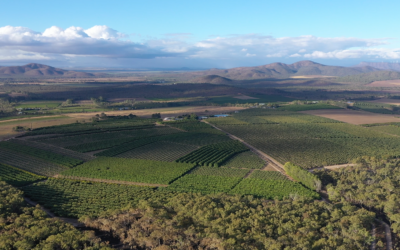
Drone imagery depicting encroachments above OLS RWY 15, for Cairns Airport.
With meticulous planning and precision, we successfully captured LiDAR imagery over the designated areas. Our findings revealed instances of vegetation encroachment above both RWY 15 OLS and RWY 33 OLS, primarily constituted by trees that breached the OLS. Throughout the project, we prioritised safety measures, ensuring our drone operations maintained a safe distance from other airspace users and remained within a visual line of sight at all times, fully compliant with CASA regulations.
Our dedication to professionalism and strict adherence to regulatory guidelines guarantee the highest level of quality and safety in our aerial services, enabling us to deliver accurate and reliable results to our esteemed clients, such as Cairns Airport.
We have also completed similar LiDAR work for QGAir of the Mareeba Helicopter landing pad. Check out the work we did in the video below!