DJI Mavic 3 Enterprise Multispectral 3M “M3M” (price excludes gst)
$6,930.00
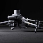
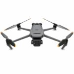
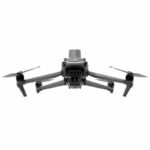
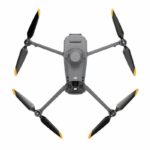
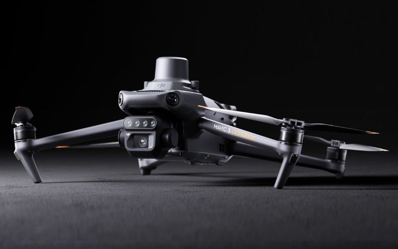
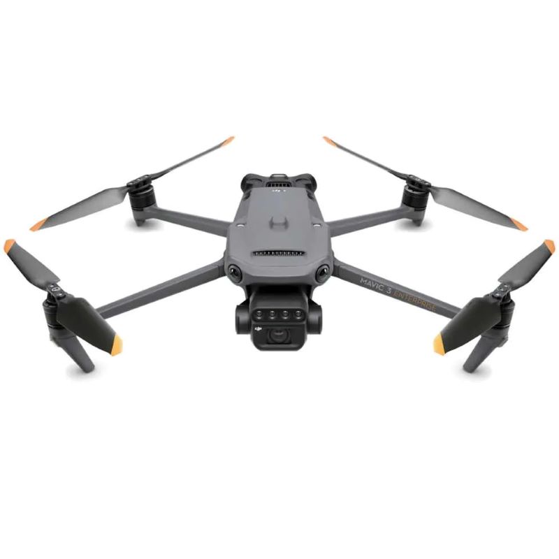
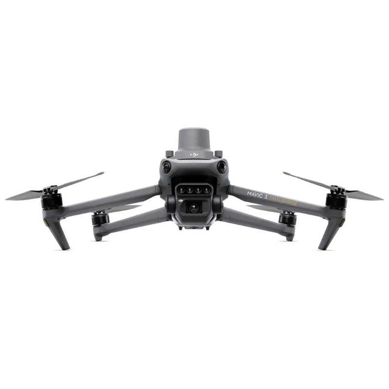
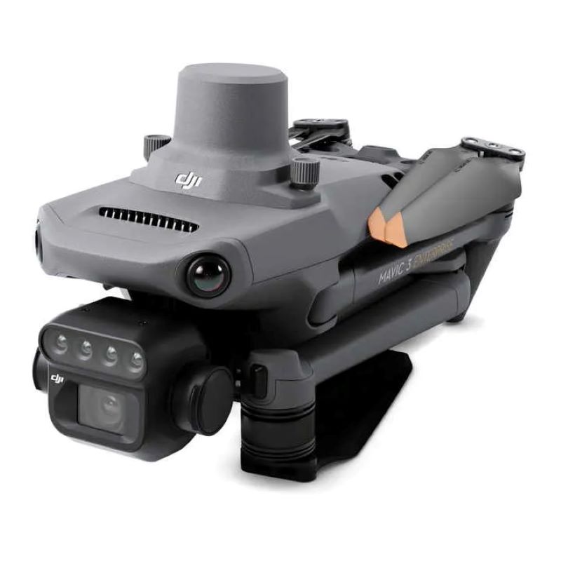
The DJI Mavic 3 Multispectral is compact and portable. It has a Multispectral Camera, RGB camera plus its safe and stable with precise positioning.
At a glance:
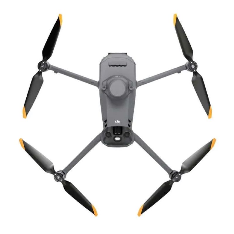
- Compact and portable
- Foldable and easy storage
- Multispectral Camera: 4 x 5MP G/R/RE/NIR
- RGB camera: 20MP
- 4/3 CMOS, mechanical shutter
- Omnidirectional Obstacle Avoidance
- 15km Transmission Distance
- Precise Centimeter-level RTK positioning
- Efficient aerial surveying
- Up to 200 hectares per flight
Code: DJIMAVIC3M
Key Features
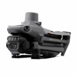
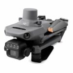
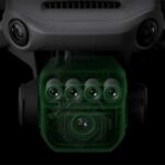
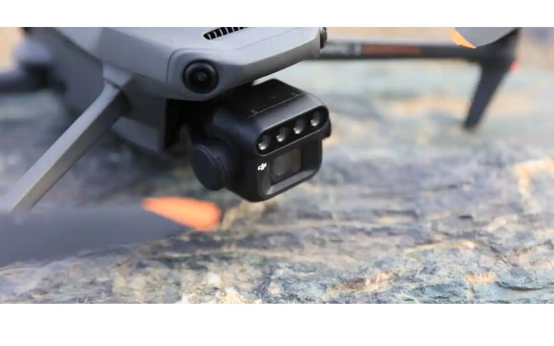
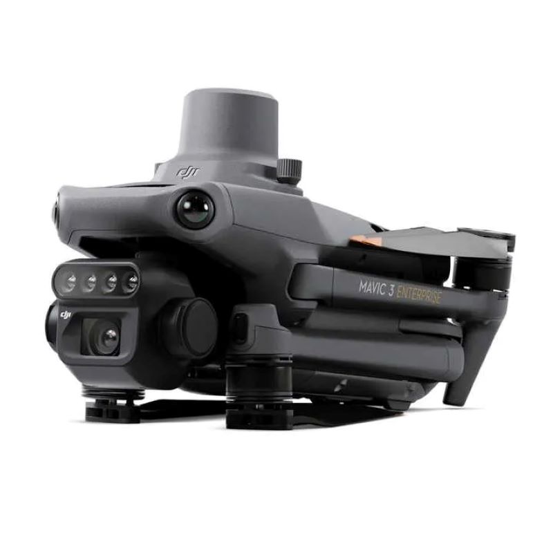
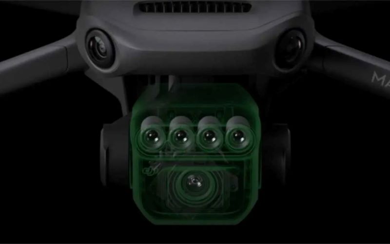
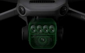
Mavic 3 Multispectral weighs 951 grams and is equipped with a dual-camera gimbal. One camera is RGB with a 4/3” 20MP CMOS sensor with a mechanical shutter having a maximum speed of 1/2000. It handles high-speed continuous shooting at the fastest interval of 0.7 seconds. The other camera is a 4-lens multispectral. Each of the four multispectral cameras can acquire 5 million pixels and scan the following wavelengths:
- Green (G): 560 nm ± 16 nm
- Red (R): 650 nm ± 20 nm
- Red edge (RE): 730 nm ± 20 nm
- Near-infrared (NIR) 860 nm ± 26 nm
By combining these two cameras, DJI Mavic 3M realizes applications such as high-precision aerial surveys, crop growth monitoring, and natural resource surveys.
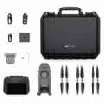
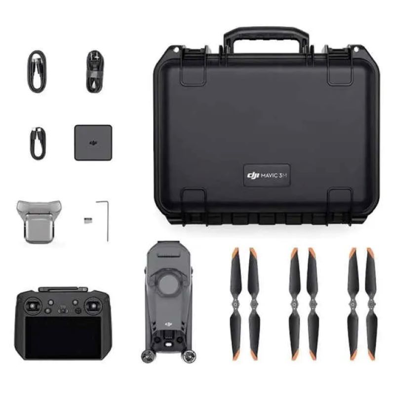
In the box:
- DJI Mavic 3 Enterprise Multispectral aircraft
- RTK module
- microSD card
- Remote controller
- 3 x propeller (pair)
- 1 x battery charger
- 1 x power cable
- 1x USB-C to USB-C cable
- 1 x carry case
- 1 x screw driver
- 1 x user manual
- 1 x DJI Terra 6 month Basic Care
- 1 x Standard Maintenance Package
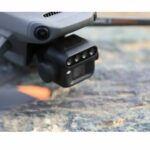
Highly Integrated Imaging System
The built-in sunlight sensor captures solar irradiance and records it in an image file, allowing for light compensation of image data during 2D reconstruction. This results in more accurate NDVI results, as well as improved accuracy and consistency of data acquired over time.
Sunlight Sensor
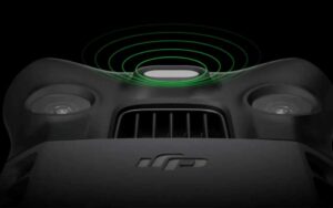 The built-in sunlight sensor captures solar irradiance and records it in an image file, allowing for light compensation of image data during 2D reconstruction. This results in more accurate NDVI results, as well as improved accuracy and consistency of data acquired over time.
Accurate images that capture every pixel
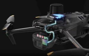
Mavic 3M with RTK module for centimetre-level positioning. Flight control, the camera, and the RTK module sync in microseconds to accurately capture the location of each camera's imaging centre. This enables Mavic 3M to do high-precision aerial surveying without using ground control points.
Efficient and Reliable Battery Life
 Ultra-long battery life, fast bursts - 43-minute flight time - 200 hectares during a single flight
Fast Charging
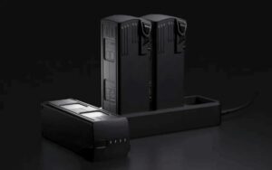
Fast charge batteries with 100W charging hub, or directly charge the drone with 88W fast charging. - Charging hub - 100W - Aircraft - 88W
Stable signal, smooth image transmission
 The O3 transmission integrates two transmitting signals and four receiving signals to support 15km ultra-long transmission distances.
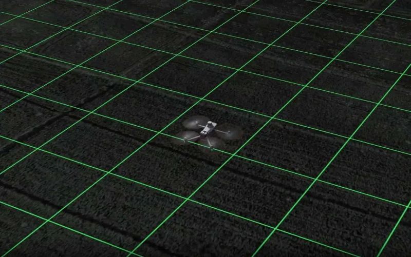
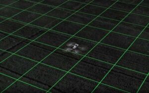
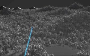
Omnidirectional obstacle sensing, terrain-follow aerial surveying
The aircraft features multiple wide-FOV vision sensors that accurately detect obstacles in all directions for omnidirectional obstacle avoidance. The terrain-follow aerial surveying can be easily performed in steep-slope landscapes.
Positioning with centimeter-level RTK
Mavic 3M includes an RTK module that achieves centimeter-level positioning. The drone, its camera, and the RTK module are synchronized at the microsecond level to accurately obtain position information from the imaging center of each camera. This enables Mavic 3M to perform high-precision aerial surveys without the use of ground control points (GCPs). And with a battery life of up to 43 minutes, Mavic 3M can complete surveying and mapping operations of an area of up to 2 square kilometers in a single flight.
Designed for safe operation
Mavic 3M features O3 video transmission, with two transmission channels and four reception channels with an operating distance of up to 15 kilometers. For added safety, Mavic 3M features omnidirectional obstacle detection to detect obstacles in all directions and help avoid them accurately.
Unlimited possibilities
Mavic 3M can be integrated into various ecosystems to offer unlimited possibilities for smart farming. Through the built-in DJI Cloud API, based on the MQTT protocol in Pilot 2, users can directly connect Mavic 3M to a third-party cloud platform to collect information, live video, photo data, and more, all without the need to develop a separate app. Mavic 3M also supports Mobile SDK 5 (MSDK5), allowing users to easily develop unique control apps for scenarios such as smart monitoring.
A new tool for precision agriculture
Mavic 3M is useful in a ‘wide variety of working scenarios. The DJI map and DJI SmartFarm platform generate an NDVI vegetation index to facilitate more efficient and localized crop treatments. Automatic field scouting can detect crop anomalies and perform intelligent analysis that enables one person to manage 70 hectares of land.
- Under 2kg - no licence required to make money flying this drone

Aircraft
| Net Weight (with propellers and RTK module) | 951g |
| Max Takeoff Weight | 1,050g |
| Dimensions (Folded/Unfolded) | Folded (without propellers): 223×96.3×122.2 mm (Length×Width×Height)
Unfolded (without propellers): 347.5×283×139.6 mm (Length×Width×Height) |
| Diagonal Length | Diagonal: 380.1 mm |
| Max Ascent Speed | 6 m/s (Normal Mode)
8 m/s (Sport Mode) |
| Max Descent Speed | 6 m/s (Normal Mode)
6 m/s (Sport Mode) |
| Max Flight Speed (at sea level, no wind) | 15 m/s (Normal Mode)
Flying forward: 21 m/s, flying sideways: 20 m/s, flying backwards: 19 m/s (Sport mode) |
| Max Wind Speed Resistance | 12 m/s |
| Max Take-off Altitude Above Sea Level | 6000 m (without a payload) |
| Max Flight Time (without wind) | 43 minutes |
| Max Hover Time (without wind) | 37 minutes |
| Max Flight Distance | 32 km |
| Max Tilt Angle | 30° (Normal Mode)
35° (Sport Mode) |
| Max Angular Velocity | 200°/s |
| GNSS | GPS + Galileo + BeiDou + GLONASS (GLONASS is supported only when RTK module is enabled) |
| Hovering Accuracy Range | Vertical: ±0.1 m (Vision Positioning enabled); ±0.5 m (GNSS Positioning enabled); ±0.1 m (D-RTK enabled)
Horizontal: ±0.3 m (Vision Positioning enabled); ±0.5 m (HD Positioning enabled); ±0.1 m (RTK enabled) |
| Operating Temperature | -10° to 40° C |
| Propeller Model Number | 9453F Enterprise Edition |
| Light Sensor | Built-in module |
| Motor Model Number | 2008 |
RGB Camera
| Image Sensor | 4/3 CMOS
Effective Pixels: 20 MP |
| Lens | FOV: 84°
Equivalent focal length: 24 mm Aperture: f/2.8 to f/11 Focus: 1 m to ∞ |
| ISO Range | 100-6400 |
| Shutter speed | Electronic shutter: 8-1/8000 s
Mechanical shutter: 8-1/2000 s |
| Max Image Size | 5280×3956 |
| Photo Shooting Mode | Single shot: 20 MP
Timelapse: 20 MP JPEG: 0.7/1/2/3/5/7/10/15/20/30/60 s JPEG + RAW: 3/5/7/10/15/20/30/60 s Panorama: 20 MP (original material) |
| Video Resolution | H.264:
4K: 3840×2160@30fps FHD: 1920×1080@30fps |
| Max Video Bitrate | 4K: 130Mbps
FHD: 70Mbp |
| Supported File System | exFAT |
| Image Format | JPEG/DNG (RAW) |
| Video Format | MP4 (MPEG-4 AVC/H.264) |
Multispectral Camera
| Image Sensor | 1/2.8-inch CMOS, effective pixels: 5 MP |
| Lens | FOV: 73.91° (61.2° x 48.10°)
Equivalent focal length: 25 mm Aperture: f/2.0 Focus: Fixed Focus |
| Multispectral Camera Band | Green (G): 560 ± 16 nm;
Red (R): 650 ± 16 nm; Red Edge (RE): 730 ± 16 nm; Near infrared (NIR): 860 ± 26 nm; |
| Gain Range | 1x-32x |
| Shutter Speed | Electronic Shutter: 1/30~1/12800 s |
| Max Image Size | 2592×1944 |
| Image Format | TIFF |
| Video Format | MP4 (MPEG-4 AVC/H.264) |
| Photo Shooting Mode | Single shot: 5 MP
Timelapse: 5 MP TIFF: 2/3/5/7/10/15/20/30/60 s |
| Video Resolution | H.264
FHD: 1920 x 1080@30fps Video content: NDVI/GNDVI/NDRE |
want to speak with an expert
Reach out to our passionate team for personalised advice.